Dave Beedon
|
all galleries
>>
Places
>>
Utah
>>
Moab (environs)
>>
Tombstone Plateau
> Domes above the Amasa Back Trail
previous
|
next
12-MAY-2014
20140512_1969
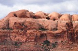
Domes above the Amasa Back Trail
view map
This view looks west-southwest across Kane Springs Canyon at the domes sitting high above the bottom portion of the Amasa Back Trail. The trail (and Kane Creek Road) is out of view below the pictured terrain.
Nikon D80
1/640s f/14.0 at 135.0mm iso400
full exif
other sizes:
small
medium
large
original
auto
previous
|
next
All images are copyright 1966 - 2023 by Dave Beedon (davebeedon AT comcast DOT net).
share
Type your message and click Add Comment
It is best to
login
or
register
first but you may post as a guest.
Enter an optional name and contact email address.
Name
Name
Email
help
private comment
Type your message and click Add Comment
It is best to
login
or
register
first but you may post as a guest.
Enter an optional name and contact email address.
Name
Name
Email
help
private comment