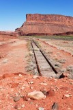
This is the southern end of Union Pacific's Cane Creek Branch at Potash, southwest of Moab, Utah. This section of track is built on a berm right next to an asphalt road, which is visible at right. Between the dark green vegetation and the dark red cliff is the Colorado River.
My vantage point was the site of a machine gun emplacement in a 1983 science-fiction movie "Spacehunter: Adventures in the Forbidden Zone."
This end of the track was where Two red locomotives were stored for a few years.
The road at right connects Potash Road, about a mile in the distance, with San Juan County Road 142, which runs to Canyonlands National Park and is often called �Shafer Trail.� The official name of the road at right is �Federal Route 1694�; it is a Grand County road that receives federal funding for maintenance.
This is the private property of Intrepid Potash. I had permission to be there.
|