lrh |
profile
|
all galleries
>>
Jasper ARK Pictures
>> "Data Dump"
tree view
| thumbnails |
slideshow
"Data Dump"
A "data dump" from the notes I've accumulated over the years. I intend to clean this up and "consolidate" it with the main POIs page and such.
2022
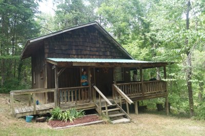
Cabin
36.013583,-93.160936
Updated coords
Old Farm Rd
Jasper
AR 72641
USA
N 36.01344, W 93.16089
Accuracy: 20 m
https://maps.google.com/maps?q=36.0134%2C-93.1609
Mexican in Harrison
Nopalitos Grill
(870) 743-1058
https://maps.app.goo.gl/qZTfqCe9MLYkRZRh7
The Fugitive Beach
https://maps.app.goo.gl/LAmtc1rJsw98CYjF6
Withrow Springs State Park
(479) 559-2593
https://maps.app.goo.gl/GzQqya7eDeexhKhJ6
Long creek
36.408609,-93.306118
-------------------
2021, Updated Coordinates
Updated coordinates 2021
Longpool
N 35.54957, W 93.16173
Accuracy: 10 m
https://maps.google.com/maps?q=35.5496%2C-93.1617
Mexican restaurant in Marshall ark
35.911778,-92.637736
Delete dog patch spot
Barn shot 07-26
N 36.25013, W 92.76463
Accuracy: 8 m
https://maps.google.com/maps?q=36.2501%2C-92.7646
Silver runs cabins are near buffalo point
Buffalo point
N 36.06948, W 92.55571
Accuracy: 4 m
https://maps.google.com/maps?q=36.0695%2C-92.5557
Pruitt
N 36.05742, W 93.13405
Accuracy: 5 m
https://maps.google.com/maps?q=36.0574%2C-93.1341
Lost valley
N 36.00908, W 93.37203
Accuracy: 4 m
https://maps.google.com/maps?q=36.0091%2C-93.372
Cafe near deer going down 16 about a mile
Gas station on 16
AR-16
Deer
AR 72628
USA
N 35.82655, W 93.28898
Accuracy: 4 m
https://maps.google.com/maps?q=35.8266%2C-93.289
New cabin
6403 US-65
Marshall
AR 72650
USA
N 35.93323, W 92.71019
Accuracy: 4 m
https://maps.google.com/maps?q=35.9332%2C-92.7102
Co Rd 414
St Joe
AR 72675
USA
N 35.94909, W 92.72604
Accuracy: 6 m
https://maps.google.com/maps?q=35.9491%2C-92.726
https://bit.ly/377OPhF
Hurricane river cave
Hasty (update)
Red bluff overlook
36.0122531, -92.6865723
Placemark for robertson to work
155 Searcy 202 Hwy
St Joe
AR 72675
USA
N 36.02988, W 92.80759
Accuracy: 4 m
https://maps.google.com/maps?q=36.0299%2C-92.8076
And
206 Badger Dr
St Joe
AR 72675
USA
N 35.99971, W 92.84845
Accuracy: 4 m
https://maps.google.com/maps?q=35.9997%2C-92.8485
------------------------
2017 (I Think most of these have already been done)
Jack's Fine Foods
I am here: 33.13850°N 94.16310°W
http://maps.google.com/maps?q=33.1385%2C-94.16311
Econo Lodge Arkadelphia ARK
I am here: 34.18429°N 93.06956°W
http://maps.google.com/maps?q=34.18429%2C-93.06956
Hardee's Benton
I am here: 34.56451°N 92.60120°W
http://maps.google.com/maps?q=34.56451%2C-92.60121
Sw spot Benton
I am here: 34.60495°N 92.61819°W
http://maps.google.com/maps?q=34.60496%2C-92.61819
Then point it here to bypass normal interstate path
I am here: 34.88380°N 92.77530°W
http://maps.google.com/maps?q=34.88381%2C-92.77531
Lake Harris Brake
I am here: 34.98546°N 92.78203°W
http://maps.google.com/maps?q=34.98546%2C-92.78204
Spot nearby river access & park
I am here: 34.99905°N 92.79798°W
http://maps.google.com/maps?q=34.99905%2C-92.79798
Took shot of tiny waterfall near Falling Water
I am here: 35.71713°N 92.95184°W
http://maps.google.com/maps?q=35.71714%2C-92.95185
Check out waterfalls p88
Six Fingers Falls
35.761504,-92.937507
https://goo.gl/maps/xDEjwXoPZoq
Waterfalls p70
36.10500, -93.26777
Kings Bluff (Pedestal?)
35.72444, -93.025
Barn shot near alum cove
I am here: 35.81296°N 93.23420°W
http://maps.google.com/maps?q=35.81297%2C-93.23421
House sale
I am here: 35.83624°N 93.38106°W
http://maps.google.com/maps?q=35.83625%2C-93.38107
P40 Family trails
I am here: 35.98322°N 93.17779°W
http://maps.google.com/maps?q=35.98323%2C-93.1778
Harrison city swim (probably not allowed)
I am here: 36.22882°N 93.10765°W
http://maps.google.com/maps?q=36.22882%2C-93.10766
I am here: 36.22882°N 93.10765°W
http://maps.google.com/maps?q=36.22882%2C-93.10766
Look out point on ARK 7
I am here: 35.97090°N 93.16863°W
http://maps.google.com/maps?q=35.97091%2C-93.16863
Roundtop
I am here: 35.98305°N 93.17766°W
http://maps.google.com/maps?q=35.98306%2C-93.17767
Barn shot Sunday
I am here: 35.93986°N 93.10139°W
http://maps.google.com/maps?q=35.93987%2C-93.10139
River off 4503
I am here: 35.95209°N 93.05723°W
http://maps.google.com/maps?q=35.95209%2C-93.05724
"Craw Hole"
36.063476,-93.127216
To check 2018
Fairview Trailhead
I am here: 35.73507°N 93.09359°W
http://maps.google.com/maps?q=35.73508%2C-93.09359
Ryan's out side Russellville
I am here: 35.11294°N 92.44091°W
http://maps.google.com/maps?q=35.11294%2C-92.44092
---------
2017
Spots She Was Interested in
Devil's Den (think swimming not allowed)
https://goo.gl/GQLKnl
Bull Shoals Lake (towards Harrison)
Tea Tables Rock
https://goo.gl/SsNioR
America's Best Value Inn Prescott ARK
33.8102941, -93.4196562
Barn off of Benton spot
N 34.61201, W 92.73925
Accuracy: 10 m
https://maps.google.com/maps?q=34.612%2C-92.7392
Old house near ArK 10
United States
N 34.88149, W 92.7735
Accuracy: 5 m
https://maps.google.com/maps?q=34.8815%2C-92.7735
Lake Sylvia
N 34.86715, W 92.82243
Accuracy: 11 m
https://maps.google.com/maps?q=34.8672%2C-92.8224
Dam at Sylvia
N 34.87096, W 92.82099
Accuracy: 11 m
https://maps.google.com/maps?q=34.871%2C-92.821
Cold Spring He Mentioned
https://www.fs.usda.gov/recarea/ouachita/recarea/?recid=10717
Other Bradley
36°00'31.0"N 93°11'25.0"W
https://goo.gl/maps/B11zre8uDPs
23rd
Barn shot (111021)
United States
N 36.25026, W 92.76435
Accuracy: 10 m
https://maps.google.com/maps?q=36.2503%2C-92.7643
Intersection in Indian Rock (hiking)
N 36.09005, W 92.57058
Accuracy: 20 m
https://maps.google.com/maps?q=36.09%2C-92.5706
Barn after Rush
United States
N 36.12534, W 92.64965
Accuracy: 11 m
https://maps.google.com/maps?q=36.1253%2C-92.6496
Trailer 40,000
United States
N 35.90489, W 93.18727
Accuracy: 14 m
https://maps.google.com/maps?q=35.9049%2C-93.1873
8707410066
Gas ARK 7
N 35.78348, W 93.1134
Accuracy: 16 m
https://maps.google.com/maps?q=35.7835%2C-93.1134
Barn shot after falling water
N 35.72614, W 93.01742
Accuracy: 10 m
https://maps.google.com/maps?q=35.7261%2C-93.0174
THE Barn Shot 74
United States
N 36.00985, W 93.30054
Accuracy: 13 m
https://maps.google.com/maps?q=36.0099%2C-93.3005
36.00962,-93.30073
I am here: 36.00970°N 93.30064°W
http://maps.google.com/maps?q=36.00971%2C-93.30064
Wed
Barn shots detour
I am here: 36.09830°N 93.14678°W
http://maps.google.com/maps?q=36.0983%2C-93.14679
Barn 43
N 36.00142, W 93.38753
Accuracy: 26 m
https://maps.google.com/maps?q=36.0014%2C-93.3875
Magnolia Wilderness Access Sign
N 35.86282, W 93.38512
Accuracy: 27 m
https://maps.google.com/maps?q=35.8628%2C-93.3851
Thur
Hammerschmidt p 60
https://goo.gl/gikgeh
Park (gravel right side by pond)
N 36.01868, W 93.28971
Accuracy: 12 m
https://maps.google.com/maps?q=36.0187%2C-93.2897
Turn left at wilderness sign
N 36.02098, W 93.28788
Accuracy: 20 m
https://maps.google.com/maps?q=36.021%2C-93.2879
Fri
Barn Mt Judea
N 35.95052, W 93.06508
Accuracy: 13 m
https://maps.google.com/maps?q=35.9505%2C-93.0651
Barn Shot where mattress flew
N 34.6118, W 92.73879
Accuracy: 23 m
https://maps.google.com/maps?q=34.6118%2C-92.7388
20220717_151409_ooc_rx100m3 (Medium).jpg
comment
|
share
Type your message and click Add Comment
It is best to
login
or
register
first but you may post as a guest.
Enter an optional name and contact email address.
Name
Name
Email
help
private comment
click on thumbnails for full image