


|
|
|
|
|
|
| |
| 14-JUN-2008 | |
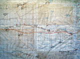
The map shows the locations of forts built to protect the railroad, and the pioneer roads west.
It also shows locations of significant Indian military actions in the area.
| Full EXIF Info | |
| Date/Time | 14-Jun-2008 13:05:27 |
| Make | Canon |
| Model | Canon PowerShot G7 |
| Flash Used | No |
| Focal Length | 12.7 mm |
| Exposure Time | 1/77 sec |
| Aperture | f/3.2 |
| ISO Equivalent | 233 |
| Exposure Bias | |
| White Balance | |
| Metering Mode | |
| JPEG Quality | |
| Exposure Program | |
| Focus Distance | |