photo sharing and upload picture albums photo forums search pictures popular photos photography help login
Reid | all galleries >> Galleries >> Western Trip > Map of Kansas late 1800's IMG_1305.jpg
previous | next
14-JUN-2008

Map of Kansas late 1800's IMG_1305.jpg

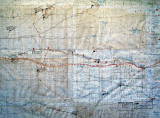
The map shows the locations of forts built to protect the railroad, and the pioneer roads west.
It also shows locations of significant Indian military actions in the area.

Canon PowerShot G7
1/80s f/3.2 at 12.7mm iso233 full exif

other sizes: small medium large original auto
share
Type your message and click Add Comment
It is best to login or register first but you may post as a guest.
Enter an optional name and contact email address. Name
Name Email
help private comment