photo sharing and upload picture albums photo forums search pictures popular photos photography help login
JSB PHOTOGRAPHS | all galleries >> passed_pads >> pad_2013 > Point to point survey of the delta ponds
previous | next
30-AUG-2013 John Burke

Point to point survey of the delta ponds

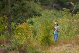
I met this really nice eugene land managemant worker named Laurie the other day,
she was at the delta ponds doing a point to point survey. She had a map and
had to go to every spot on it at the delta ponds and take a picture every
month. This is her 10th year doing this. When I mentioned my good
friend Vern Rodgers, she got exited and said that the other lady
she works with has used his pictures for the city of eugene
before. As we where talking she showed me some
pictures of the delta pond gong back
ten years, it was unbelievable
how much it has
changed there!


other sizes: small medium original auto
share
Joey Walden16-Mar-2015 22:27
I remembered doing land surveying a few years ago. It's amazing how much has changed in that time frame. I visited a place that was no longer sending people out to do the surveying, but are now using drones to land survey for them. http://www.wittlandsurveying.com/services
fotabug30-Aug-2013 23:30
Excellent shot, John. She looks a bit familiar but I am not sure. You are right, it is amazing how much things have changed. I remember when the ponds were just gravel pits, left over from the building of I-5. What Eugene Parks has done to reclaim and restore it is wonderful! They received an award from the State for their work. The State used a couple of my photos in their announcement of the award. What a blessing Eugene's parks have been for us!
Commenting on this page requires a PBase account.
Please login or register.