Silvaplana has an area, as of 2006, of 44.7 km2 (17.3 sq mi). Of this area, 19.6% is used for agricultural purposes, while 14.1% is forested. Of the rest of the land, 2.2% is settled (buildings or roads) and the remainder (64.1%) is non-productive (rivers, glaciers or mountains).
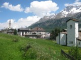
Silvaplana is located on Lake Silvaplana in the Upper Engadine Valley. It is located in the Oberengadin sub-district of the Maloja. Above the village at 2,284 m (7,493 ft), the Julier Pass connects the Engadine valley to the rest of Graubünden and the Rhine watershed. While the stream Ova dal Vallun which connects Lake Silvaplana and Lake Champfčr runs through the village. It consists of the village of Silvaplana and the hamlets of Surlej and Albana as well as part of the village of Champfčr.


Please login or register.