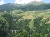
Ftan has an area, as of 2006, of 43.1 km2 (16.6 sq mi). Of this area, 40.6% is used for agricultural purposes, while 15.4% is forested. Of the rest of the land, 1.2% is settled (buildings or roads) and the remainder (42.8%) is non-productive (rivers, glaciers or mountains).
The municipality is located in the Suot Tasna sub-district of the Inn district on a terrace above the left bank of the Inn river. It consists of the village sections of Ftan Grond and Ftan Pitschen. Until 1943 Ftan was known as Fetan


Please login or register.