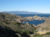
The peninsula of Cap de Creus constitutes the last buttress of the Pyrenees and the easternmost point of the Iberian Peninsula. The coast is abrupt and jagged, with towering cliffs and remote coves. It is the first natural park in Catalonia covering areas of both sea and land, and was created in 1998.
The total area of the Park is 13,886 hectares, of which 10,813 are on land and 3,073 are at sea. Within the land area there are 3 natural zones of declared national interest (PNIN): to the North, the sector around Cap Gros-Cap de Creus; to the South, the sector around Punta Falconera-Cap Norfeu; and to the West, the sector of the Serra de Rodes. All the islands and islets located within the maritime area of the Natural Park also have the same status..


Please login or register.