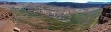
This panorama was made with 4 handheld shots of the area above where upper Lake Powell used to be. Lake Powell has suffered from 5 years of drought and from demand for power at the Glen Canyon Dam. It is over 125' lower than it's high point of 10 years ago and it's believed that it may never return to it's old levels. In this photo, most of the lower portions of the land were once covered by the lake and now the Colorado river has returned to it's banks (follow the cliff edge below where I was standing). What looks like a landing strip in the photo is actually the boat ramp at Hite, which was added onto a few times before it was abandoned a couple years ago. Southeast Utah.