


|
|
|
|
|
|
| |
| 20-Feb-2010 | Jim Stiles |
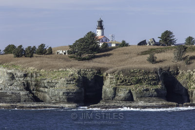
Cape Flattery Light and Tatoosh Island
Tatoosh Island is a small island and small group of islands about 0.5 miles (0.8 km) offshore (northwest) of Cape Flattery, which is on the northwestern tip of the Olympic Peninsula in Washington. Tatoosh is the largest of a small group of islands also often referred to as simply "Tatoosh Island", which are almost as far west as Cape Alava, about 15 miles (24 km) to the south and the westernmost point in the contiguous 48 states. The islands are part of the Makah Reservation and a part of Clallam County. The total land area of the island group is 159,807 square meters (39.489 acres).
Historically, Tatoosh Island was inhabited seasonally by Makah fishing camps and employees of the United States Coast Guard, Weather Bureau, and Navy. Currently there is no resident population on the islands. Access to the island requires written permission of the Makah tribe. The island's name comes from a Makah chief known as Tatoosh (also Tatooche or Tetacus).
Tatoosh Island has been home to Cape Flattery Light, which overlooks the entrance to the Strait of Juan de Fuca, since December 28, 1857.
© Jim Stiles. All images are protected by US and International copyright laws. All Rights Reserved.