


|
|
|
|
|
|
| |
| 07-JAN-2008 | |
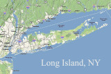
Long Island is 118 miles (190 km) in length and varies in width between 12 and 23 miles (19-37 km). It has an area of 1401 square miles (3629 sq. km). It's political divisions are the New York City Boroughs of Queens and Brooklyn and the counties of Nassau and Suffolk. LI is the most populated island in any U.S. state or territory with 7,448,618 people as of the 2000 census.
Photographer's Note: Click on "View Map" to see the various locations I have taken pictures on Long Island and vacinity.
| comment | |
| Jim's Atavistic Visions | 20-Aug-2009 04:07 | |