photo sharing and upload picture albums photo forums search pictures popular photos photography help login
Jerry Pillarelli | profile | all galleries >> Travel and Nature; Sites by State >> US Travel; by Trip, by State >> Montana >> Earthquake Lake Geologic Area – Montana tree view | thumbnails | slideshow

Earthquake Lake Geologic Area – Montana

Images of Earthquake Lake Geologic Area – Southwestern Montana, taken in July 2021.

On August 17, 1959 one of the most powerful earthquakes ever recorded in the Rocky Mountains, 7.5 on the Richter Scale, destroyed the Madison River Valley and killed 28 people while also creating a new lake behind a massive 80-million-ton landslide. The earth’s crust dropped 19-feet along the Hebgen Fault and the land under Hebgen Lake tilted causing huge waves to crest over the Hebgen Dam.

The Earthquake Lake Geologic Area in the Gallatin National Forest, run by the US Forest Service, protects this area and tells the story of the night which altered this valley forever. The centerpiece is Earthquake Lake and the landslide which created it but it is the stories of survival and those lost during the episode, from Hilgard Lodge to Halford’s Camp and the Ghost Trees of the campgrounds now under water that resonate. It is a reminder of the awesome forces of nature which can change the world around us in an instant.
The landslide area viewed over Earthquake Lake in Earthquake Lake Geologic Area
Mountain altered by the 7.5 earthquake in Earthquake Lake Geologic Area
Slide area along the Madison River in Earthquake Lake Geologic Area
Side view of the landslide area in Earthquake Lake Geologic Area
Some of the 80 million tons of rock landslide in Earthquake Lake Geologic Area
The Memorial Boulder with the names of the 28 people who perished in Earthquake Lake Geologic Area
Remnants of the landslide including the Memorial Boulder (left) in Earthquake Lake Geologic Area
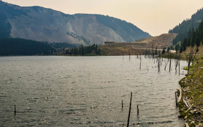
View of Earthquake Lake, formed the night of the earthquake, in Earthquake Lake Geologic Area
Ghost trees, once part of the valley, in Earthquake Lake in Earthquake Lake Geologic Area
Earthquake Lake ghost trees in Earthquake Lake Geologic Area
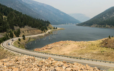
Ghost trees along US Highway 287 in Earthquake Lake Geologic Area
Earthquake Lake ghost trees in Earthquake Lake Geologic Area
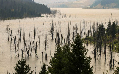
Forest of ghost trees jut out of Earthquake Lake in Earthquake Lake Geologic Area
Cabin Creek fault scarp, 19-foot drop in the campground, in Earthquake Lake Geologic Area
Fault scarp, 19-foot drop in the campground, at Cabin Creek in Earthquake Lake Geologic Area
Dead tree reflected in the waters of a small pond in Earthquake Lake Geologic Area
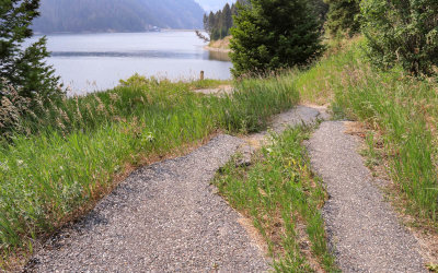
Snake along the Ghost Village Overlook Trail in Earthquake Lake Geologic Area
Mountain from along the Ghost Village Overlook Trail in Earthquake Lake Geologic Area
Warning I saw ‘after’ I hiked the Ghost Village Overlook Trail in Earthquake Lake Geologic Area
Grasses reflected in a pond in Earthquake Lake Geologic Area
US Highway 287 where it collapsed into Hebgen Lake in Earthquake Lake Geologic Area
View of the remains of a cabin from Halford’s Camp in Earthquake Lake Geologic Area
Two Halford’s Camp cabins, part of the ‘Ghost Village’, in Earthquake Lake Geologic Area
A Halford’s Camp cabin washed away by the earthquake in Earthquake Lake Geologic Area
Remains of a ‘Ghost Camp’ cabin in Earthquake Lake Geologic Area
Ruins of the Hilgard Lodge on Hebgen Lake in Earthquake Lake Geologic Area
A Hilgard Lodge cabin on the banks of the Hebgen Lake in Earthquake Lake Geologic Area
Hilgard Lodge cabin destroyed by the earthquake in Earthquake Lake Geologic Area
Remains of the Hilgard Lodge in Earthquake Lake Geologic Area
Hilgard Lodge foundation in Hebgen Lake in Earthquake Lake Geologic Area