photo sharing and upload picture albums photo forums search pictures popular photos photography help login
Deems Burton | all galleries >> The Salmon Trinity Alps Wilderness >> Trinity Alps High Route 2012 > Trinity Alps High Route 2008 Map
previous | next
July 2008

Trinity Alps High Route 2008 Map

Trinity Alps Wilderness

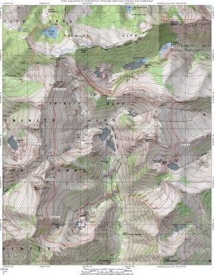
This is the route I followed for a week. It plots out to only 25 miles; however it will feel like 100 miles with the elevation ups and downs, the off trail rock work, snowfield traverses, and route finding challenges. It is a high risk adventure, with rescue days away or non-existent. Only those with skills in rock climbing, route finding in difficult terrain, light weight backpacking, and the ability to make sound decisions in difficult situations should consider this adventure. It's one of my favorite hikes.

Trinity Alps High Route.kml is the route traced on Google Earth 6 . Save the file, and click to open route on GE (added 12/2010)

Topo Map Program hide exif
Full EXIF Info
Date/Time
Make
Model
Flash UsedNo
Focal Length
Exposure Time
Aperture
ISO Equivalent
Exposure Bias
White Balance
Metering Mode
JPEG Quality
Exposure Program
Focus Distance

other sizes: small medium large original auto
previous | next
share
Trinity 29-Apr-2014 23:51
Francisco, I'm 22 an have always wanted to hike the high route. Any chance I could join you and your buddy? I'm fit and have lots of experience high in the Trinities off trail. Let me know! tleonard@mit.edu
Francisco 12-Feb-2014 19:18
I absolutely love what you have accomplished in the Trinity Alps. I've been there numerous times. A buddy of mine and myself are hoping to attempt your high route this summer. We are 23 years old and ready for a challenge. How much rock climbing experience do you need to complete the route? Any suggestions would be appreciated.
mike 24-Oct-2012 14:44
This is the same routes we do in winter and spring to ski. We have a few others that are worthy as well
Bill Geller 24-Aug-2012 01:22
Hi - thank you for the time and effort to put this loop together and for sharing just enough through the pictures to not spoil all the route finding. My 2 brothers and I just did it - we are ages 55- 65. We will be happy to share our pictures and write up if you or anyone reading this are interested. (geller@maine.edu). Do you know how many people have actually done this loop? It is incredibly demanding physically and mentally and we've been doing this stuff consistently since we were kids. We saw a boot track and dog tracks on the Alpine Lake side of the pass coming south from Smith Lake - was that you? - Bill, John, Jim
Monte Dodge24-Jun-2012 15:02
Wonderful trip!!
Guest 09-Oct-2011 01:50
Beast Master
Guest 01-Dec-2008 00:54
WOW , THATS SOME HIKE/TRAVERSE/CLIMB/ADVENTURE !!!!!!!!!!!!!!AFTER THE FIRES STARTED JUNE 20 , 2008 , I DIDNT THINK ANYONE WOULD BE IN THE ALPS ? I KNOW IT TURNED ME BACK ? GOOD LUCK
Monte Dodge08-Jul-2008 05:00
Hats off to you for survivi ng this trip.. Great job and an adventure few hikers would be able to pull off. Talk about " Laying It On The Line ",,, bigvote,,, love to see you do a talk on this,,vote
Type your message and click Add Comment
It is best to login or register first but you may post as a guest.
Enter an optional name and contact email address. Name
Name Email
help private comment