


|
|
|
|
|
|
| |
| 25-MAR-2008 | |
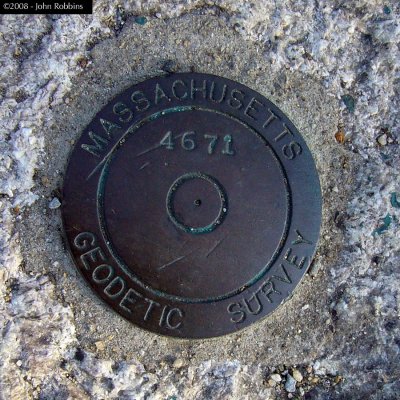
Massachusetts Geodetic Survey vertical mark stamped 4671. Elevation is 9.581 feet
above mean sea level. The official description for this mark (from the MA G.S. web site) is:
MEMORIAL DRIVE, BETWEEN HARVARD BRIDGE AND LONGFELLOW BRIDGE, ABOUT 60 FT EAST
OF ENTRANCE TO CHARLES RIVER YACHT CLUB ACROSS FROM 100 MEMORIAL DRIVE,
59.6 FT WEST OF MANHOLE, 30.0 FT SOUTH OF LIGHT POLE, 39.0 FT SOUTHWEST OF
SOUTHWEST CORNER OF PARK BENCH CONCRETE BASE, 2.2 NORTHWEST OF IRON FENCE POST.
| Full EXIF Info | |
| Date/Time | 25-Mar-2008 16:07:30 |
| Make | Panasonic |
| Model | DMC-FX9 |
| Flash Used | No |
| Focal Length | 5.8 mm |
| Exposure Time | 1/125 sec |
| Aperture | f/2.8 |
| ISO Equivalent | 80 |
| Exposure Bias | |
| White Balance | |
| Metering Mode | matrix (5) |
| JPEG Quality | |
| Exposure Program | program (2) |
| Focus Distance | |
Unless otherwise claimed, all photos are © 2001-2025, John Robbins. All rights reserved.
| comment | |