photo sharing and upload picture albums photo forums search pictures popular photos photography help login
Deems Burton | all galleries >> Galleries >> Wind River Range of Wyoming > Winds'97 Map in Titcomb Basin
previous | next
Aug 1997 D Burton

Winds'97 Map in Titcomb Basin

Wind River Mountains

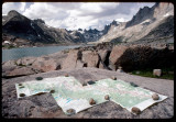
This adventure started at Big Sandy TH to Cirque of Towers, over Texas Pass, to Pyramid lake, to Raid Lake xc, and north to Titcomb Basin on the High Trail. 12 days, 85 miles. Here, as usual, it was very windy in the Winds, thus the rocks.


other sizes: small medium large original auto
share
Terri Steele13-Mar-2007 21:21
Yes, I agree.... vote!
Monte Dodge13-Mar-2007 15:33
Big vote,,, Very creative shot!!!!! Nice
Type your message and click Add Comment
It is best to login or register first but you may post as a guest.
Enter an optional name and contact email address. Name
Name Email
help private comment