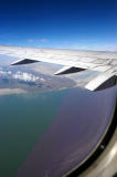
During the ascent to cruising altitude on a flight from Salt Lake City to Seattle, I saw
this odd-looking scene. This view is to the southwest and shows the railroad causeway that
crosses Great Salt Lake from east to west, dividing the lake into two parts, north and south.
The causeway appears at the center of this WikiMapia aerial view.
The different colors of the water reflect the different levels of algae therein: the north
side (at right) has a higher concentration of the stuff, causing a pinkish color that is
visible in this photo taken at Spiral Jetty. Freight trains of the Union Pacific Railroad use
this causeway daily, running between Ogden, Utah, and points in California. The
point in the photo where the causeway joins land is called Lakeside; it sits at
the north end of the Lakeside Mountains and is "out in the middle of nowhere."
Beyond it is about 40 miles of straight-as-an-arrow track.
The thin white lines in the purplish area are marks on the airplane's window.
.