It has been determined that the scribe has written the name as Thomas Boyle, not Boyte based on closer analysis of the handwriting. See YDNA matches and medieval records found in Ireland for this line which has current spelling as Boyt, Boyte, Boyett/e. http://pbase.com/daveb/g2
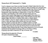
THOMAS BOYLE, 129 acs., Up. Par. of Nansemond Co; S. side of the back Sw. of Sumerton; 28 Oct. 1697, p. 110. Adj. Thoms Jernakan & land of Samll. Watson. Trans of 3 pers: John Wike, William Walker, Humphry Minson.
Same book and ON THE SAME DATE (which no doubt is our BOYTE) note:
SAMUEL WATSON, 128 acs., Up. Par of Nansemond Co; S. side of the back Swamp of Sumerton; adj. his own; BOILE'S LINE; & land of Wm. Howell; 28 Oct. 1697, p. 121. Trans of 3 pers; James & Jos. Shriff, Geo. Jones.
On page 26 of the same book:
HENRY JENKINS, 665 acs., Up. Par. of Nansemond Co; on NW side of the Back Swamp;
6 June 1699, p. 195. Beg. at a fork or point made by sd. swamp & the long branch;
ADJ. THOMAS BOYT. Trans. of 14 pers:
Title Boyle, Thomas. (Thomas Boyle)
Publication 28 October 1697.
Other Format Available on microfilm. Virginia State Land Office. Patents 1-42, reels 1-41.
Related See also the following surname(s): Boile.
Note Location: Nansemond County.
Description: 129 acres on the south side of the Back Swamp of Sumerton, adjoining the land of Thomas Jornakan, &c.
Source: Land Office Patents No. 9, 1697-1706 (v.1 & 2 p.1-742), p. 110 (Reel 9).
Part of the index to the recorded copies of patents for land issued by the Secretary of the Colony serving as the colonial Land Office. The collection is housed in the Archives at the Library of Virginia.
(NOTE: SAME DATE, CONNECTS TO THE JENKINS LAND PATENT AND CONFIRMS SPELLING AS BOYTE, SEE 1799 PATENT) Also See William King
http://image.lva.virginia.gov/cgi-bin/drawer?retrieve_image=LONN&dir=/LONN/LO-1/009/009&image_number=0131&offset=%2B21&name=Patents+No.9+1697-1706+(VOL.1+%26+VOL.2)&dbl_pgs=no&round=
URL (Click on link) http://image.lva.virginia.gov/cgi-bin/GetLONN.pl?first=103&last=&g_p=P9&collection=LO Patent
Author Link King, Wm. grantee. (William King)
Title Link Land grant 28 October 1697.
Summary Location: Nansemond County.
Description: 260 acres on the north west side of the Back Swamp of Summerton. Beg.g at a marked pine standing on the N. Wt. side of the Backswamp of Sumerton a corner tree of the land in controversy between Henry Jenkins and Thomas Jornakin.
Source: Land Office Patents No. 9, 1697-1706 (v.1 & 2 p.1-742), p. 103 (Reel 9).
Part of the index to the recorded copies of patents for land issued by the Secretary of the Colony serving as the colonial Land Office. The collection is housed in the Archives at the Library of Virginia.
Other Format Available on microfilm. Virginia State Land Office. Patents 1-42, reels 1-41.
Subject - Personal Link King, Wm. grantee.
Link Jenkins, Henry.
Link Jornakin, Thomas.