


|
|
|
|
|
|
| |
| Copyright 2003 Robert | |
Click on 'orginal' for the best resolution.
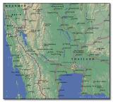
Shown here are Bangkok,
Kanchanaburi, and Thanbyuzayat. Two of the Allied P.O.W. cemeteries are in Kanchanaburi, Thailand while the third is in Thanbyuzayat, Burma.
Kanchanaburi is connected by daily road and rail services with Bangkok and other neighbouring provinces. Air-conditioned and non-airconditional coaches leave Bangkok's
Southern Bus Terminal throughout the day for the 2 to 3-hour journey while trains leave the Bangkok Noi Railway Station two times daily for Kanchanaburi.
We chose to go by car from Bangkok. From the centre of Bangkok, head for Phra Pinklao Bridge. Cross the bridge and continue along Pinklao Road for 35 km until you
reach the junction with Route 4. Turn right, following the signs for Ratchaburi. Just past Nakhon Pathom, look for the flyover and the sign for Kanchanaburi. Take the
flyover and continue along the A323 to Ban Pong. From Bang Pong, follow the signs to Kanchanaburi (a further 50km). When you reach Kanchanaburi, pass through
the town, and follow the signs to the War Cemetery. The cemetery is located about 1.5km west of the city center.
Posting to a public website does not imply public domain. All photos are subject to Copyright Laws.
| comment | |