https://dc.lib.unc.edu/cdm/ref/collection/ncmaps/id/467
Repository North Carolina Collection Gallery
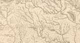
Title A Compleat map of North-Carolina from an actual survey
Date Published 1770
Date Depicted 1770
Creator - Individual Collet, John. Bayly, J. Hooper, S. (Samuel)
Place of Publication London
Publisher S. Hooper
https://www.ncpedia.org/greens-path
Green's Path was one of the principal routes used during the second and third quarters of the eighteenth century by settlers moving south from Virginia into those sections of the Roanoke, Tar, Neuse, and Cape Fear River basins that lay in the inner coastal plain of North Carolina.
Bryan and Green Families
Could the Roger Green of Green's Path (1611-1671) be the same Green family who is directly related to Needham Green Bryan of Smithfield, NC (On the Neuse River)? Or was it the John Green's Path?
AI Overview
Green's Path, an old Indian trade route used by settlers moving from Virginia to North Carolina in the 18th century, is linked to both John Green and Roger Green.
Here's a breakdown:
Roger Green: An Anglican minister in Virginia, Reverend Roger Green petitioned the Virginia Assembly in 1653 for land south of the Roanoke River, according to NCpedia. He promoted migration to neighboring lands in North Carolina.
John Green: Other sources, citing early Edgecombe County court records, suggest the path was named after John Green, whose family moved from Virginia to the Roanoke River settlements around 1715.
In summary: There are differing accounts regarding whether the path was named for John Green or Roger Green, with strong evidence suggesting both played a role in the settlement of the area.
https://ancestors.familysearch.org/en/MK35-MFF/needham-green-bryan-1796-1837
Roger Green (1611 - 1671)
Born 1611 in Norfolk, England
Died 1671 at about age 60 in Charles City, Charles City County, Virginia
https://www.wikitree.com/wiki/Green-2700
Family Tree of Farnifold Green
https://www.wikitree.com/wiki/Green-2699
Family Tree of Needham Bryan
https://www.wikitree.com/wiki/Bryan-5705#Ancestors
History, The Heritage of Johnston County North Carolina - 1985 The Heritage of Johnston County North Carolina 1985 Published by The Heritage of Johnston County Book Committee in cooperation with The History Division Hunter Publishing Company Winston-Salem, North Carolina
History, The Heritage of Johnston County North Carolina - 1985 BRYANS OF MILL CREEK 157
https://www.bmgen.com/document/pdf/History_The_Heritage_of_Johnston_Co_NC_1985.pdf
Routes of migration and trade
The first European and African settlers came from coastal N.C. and the Tidewater areas of Virginia and Maryland, many traveling along Green's Path, an old Indian trade route apparently named for Roger Green, an Anglican minister in Virginia who promoted migration to neighboring lands in North Carolina. These early settlers were primarily subsistence farmers who grew little more than was required to feed and clothe their families. Some made profits by raising large herds of swine and cattle which they drove to markets in Virginia. A few grew tobacco which they hauled on wagons to Virginia or shipped down the Neuse River to New Bern, and from there to Norfolk.
Smithfield, Johnston's first town, grew up at the site of Smith's Ferry on the Neuse River. The courthouse was moved there in 1771, and the town was incorporated in 1777. In 1770 the colonial assembly had attempted to boost North Carolina's tobacco trade by erecting a warehouse near Smith's Ferry for receiving and storing tobacco to be shipped down the Neuse River to the sea. Nonetheless, it would be another century and a quarter before this product would gain the attention of Johnston's commercial farmers.
https://www.johnstonnc.gov/heritage2/hccontent.cfm?PID=history
https://nclandgrants.com/query/
William Bryant Johnston 1746 100 So. side of Neuse River 0229 Unxd
Needham Bryant Johnston 1752-04-07 1747 250 S. side of Black river 59 PtBk|Unxd
Hardy Bryan Johnston 1752 200 0244 Unxd
William Bryant Johnston 1755-10-10 1755 500 S. side of Neuse River 125 PtBk|Unxd
John Browne Johnston 1757-11-26 1755 450 S. side of Falling Creek 160 PtBk|Unxd
John Bryan Johnston 1756-10-13 1755 200 On the No. side of Neuse River and on the So. Wt. side of Mogason Pocosin 948 PtBk|Unxd
Thos. Brown Johnston 1757 300 In the fork of Falling Creek 0230 Unxd
Lewis Bryan Johnston 1758 200 On a branch of Mill Creek 067 Unxd
Tho. Brown Johnston 1759 160 On Dees Medow branch 0253 Unxd
Needham Bryan Johnston 1774-07-21 1772 300 Beg. at a stake it being the third corner of John Smithsland 1388 PtBk|Unxd
Needham Bryan Johnston 1774-07-22 1772 250 On the North side of Neuse River 1457 PtBk|Unxd
Needham Bryan Johnston 1774-07-22 1773 150 On the North side of Neuse River 1458 PtBk|Unxd
Needham Bryan Johnston 1774-07-22 1773 100 On the North side of Neuse River on Polecat Swamp 1459 PtBk|Unxd
John Brown Johnston 1773 250 So. side of Neuse River So. side of Black Creek 065 Unxd
William Bryan Johnston 1778-12-12 1778 250 S. side Neuse River 1519 PtBk|Unxd
William Bryan Johnston 1778-12-12 1778 340 S. side Neuse River and Middle Creek 1521 PtBk|Unxd
Needham Bryan Johnston 1778-12-12 1778 300 N. side Neuse River on a prong of Polecat 1522 PtBk|Unxd
Hardy Bryan Johnston 1778-12-12 1778 340 S. side of Neuse River 1528 PtBk|Unxd
William Bryan Johnston 1778-12-12 1778 172 S. side Neuse River in fork of Middle Creek 1548 PtBk|Unxd
Needham Bryan Johnston 1779-12-30 1778 300 On Black Creek 1791 PtBk|Unxd
John Brown Johnston 1778-12-12 1778 100 S. side Neuse River 1543 PtBk|Unxd
Kedar Bryan Wake 1779-08-09 1778 340 On the South side of Neuse River and on both sides of Poplar Branch 606 PtBk|Unxd
William Brown, Jr Wake 1779-08-09 1778 397 On both sides of the Dutchmans Branch [Creek] 21 PtBk|Unxd
Asa Bryan Johnston 1779-07-01 1778 200 N. side of Bushes Creek 1636 PtBk|Unxd
Arthur Bryan Johnston 1778-12-12 1778 200 S. side Neuse River 1560 PtBk|Unxd
Needham Bryan Johnston 1779-12-30 1778 240 The South side of Neuse River on the North side of the Spring Branch 1778 PtBk|Unxd
Lewis Bryan Johnston 1778-12-12 1778 450 On the North side of Neuse River 1577 PtBk|Unxd
Thomas Brown Wake 1779-08-09 1778 200 On both sides of Bryar [Briar] Creek 71 PtBk|Unxd
Burwell Barnes Wake 1780-04-01 1778 388 On both sides of Upper Bartons Creek 412 PtBk|Unxd
Thomas Brannon Wake 1779-08-09 1778 625 On the North side of Neuse River and on both sides of Poplar Creek 683 PtBk|Unxd
Needham Bryan Johnston 1779-12-30 1778 640 On the North side of Neuse beg. at a stake 1858 PtBk|Unxd
John Bryan Johnston 1779-07-01 1778 400 S. side of S. prong of Mill Creek 1617 PtBk|Unxd
Lewis Bryan Johnston 1779-07-01 1778 150 N. side of Bushes Creek 1658 PtBk|Unxd
Needham Bryan Johnston 1778-12-12 1778 320 N. side Neuse River 1538 PtBk|Unxd
John Bryan Johnston 1779-07-01 1778 200 N. side of Bushes Creek 1602 PtBk|Unxd
Needham Bryan Johnston 1779-12-30 1778 240 On the North side of Neuse River 1677 PtBk|Unxd
Needham Bryan Johnston 1779-12-30 1778 200 On the North side of Neuse River on the Branches of Polecat Swamp 1684 PtBk|Unxd
Hardy Bryan Johnston 1779-12-30 1778 200 On the South side of Neuse River on both sides of the roadthat leads from Johnston old Court house 1696 PtBk|Unxd
Searching Johnston County plus bordering counties: Franklin, Harnett, Nash, Sampson, Wake, Wayne, Wilson
Name County Issued Entered Acres Location File # Details/Images ...
George Boyette Johnston 1800-11-14 1797 400 Beg. at a Pine Patrick Oneals corner 3342 PtBk|Unxd
Name County Issued Entered Acres Location File # Details/Images ...
James Boyett Wayne 1782-10-25 1779 100 On both sides of Black Swamp. 21 PtBk|Unxd
William Boyett Nash 1782-10-25 1780 214 South side of Tarr River 188 PtBk|Unxd
Amos Boyett Wayne 1789-11-27 1780 100 On the East side of Little River beg. at a small red oak. 322 PtBk|Unxd
Sarah Boyett Johnston 1783-10-09 1780 100 Joining James Watsons line 2348 PtBk|Unxd
Amos Boyett Wayne 1789-11-27 1788 189 N. side of Little River. 323 PtBk|Unxd
Benjamin Boyett Wayne 1790-11-17 1789 25 S. side of Buck Swamp. 415 PtBk|Unxd
Henry Boyett Wayne 1813-12-23 1813 36 On S. side of Huckleberry Branch. 1022 PtBk|Unxd
Name County Issued Entered Acres Location File # Details/Images ...
Joseph Boyt Wayne 1783-10-09 1780 50 No. side of Neuse River So. side of Marsh Branch. 60 PtBk|Unxd
James Boyt Wayne 1785-09-30 1780 125 On the North side of Little river and Buck Swamp. 78 PtBk|Unxd
Joseph Boyt Wayne 1785-09-30 1783 45 On the East side of the Marsh Branch. 92 PtBk|Unxd
Searching Edgecombe County plus bordering counties: Halifax, Martin, Nash, Pitt, Wilson
where Name exactly "Boyett" 2 results found and displayed below
Name County Issued Entered Acres Location File # Details/Images ...
Solemon Boyett Martin 1784-11-10 1778 200 Beg. at Loverd Pearce [Lovick Pierce] and Christopher Hinescorner a pine 180 PtBk|Unxd
William Boyett Nash 1782-10-25 1780 214 South side of Tarr River 188 PtBk|Unxd
https://digital.lib.ecu.edu/encore/ncgre000/00000018/00017023/00017023.pdf
Select above link and after it loads, select the download icon to download back to your computer. Well worth the read. Too large to send by email.
They Passed This Way, A Personal Narrative of Harrett County History
by Malcolm Fowler, 1955
Johnston County was created in 1746 from Craven County and named in honor of Gabriel Johnston, North Carolina's royal governor at the time. Johnston County originally contained most of what is now Wake, Wayne, Greene, and Lenoir counties and part of Wilson.
AI Overview
Based on your query, the most relevant figure is
Gabriel Johnston, who served as the Royal Governor of North Carolina from 1734 to 1752. This places his tenure within the early to mid-1700s, aligning with your request.
Here are some key facts about Governor Gabriel Johnston:
Scottish Background: He was born in Scotland and was educated at the Universities of Edinburgh and St. Andrews.
Longest-Serving Governor: Johnston served for 18 years, the longest tenure of any North Carolina governor.
Encouraged Scottish Immigration: He actively encouraged immigration, particularly from his native Scotland, contributing to a significant increase in the province's population. He also offered favorable land prices and tax exemptions to help new Scottish settlers establish themselves.
Relocation of Capital: He moved the colonial capital of North Carolina to Newton in 1739 and renamed it Wilmington in honor of his patron, Spencer Compton, the Earl of Wilmington.
Accomplishments and Challenges: Despite facing internal conflicts within the colony and receiving little support from London, Johnston implemented several reforms, including bringing the first printer to the colony, publishing its laws, and building forts. He also addressed issues like the misuse of land patents and quitrents.
Concerns about the Colony: Johnston was reportedly disturbed by the moral laxity, disregard for law, inadequate educational facilities, and oppression of the poor in North Carolina.
While Johnston served as governor during a significant portion of the early 1700s, it's worth noting that Samuel Johnston, his great-nephew, also served as North Carolina's governor, but his term was much later, from 1787 to 1789.