


|
|
|
|
|
|
| |
| 10-Jul-2006 | AKMC |
8 seconds have elapsed since the previous (published) shot. Instead of continuing to look out the side, I looked forward. In that time I missed the opportunity to shoot all the way across South Coogee and into Coogee proper. The distance as the helo flies is about 2.5km (1.5 miles) ... but it's 1.5 miles that will be forever missed since I'll obviously never be back there on that day so many years ago.
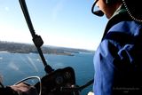
While it can be useful to maintain situational awareness, on a photography flight it's probably sometimes better to forsake that for focus. Obviously the view of the front window was obstructed from the back seat, and there was quite a bit of internal reflection to contend with.
Going left to right, I believe that the sandy beach on the left is the topmost end of Coogee Beach, with the bit jutting out from it being Dolphin Point on which you will find (but maybe not in this picture) the Giles baths. (No, I have no idea who they were named after either. Neither does Randwick Council, probably.)
The headland running to the right (north-ish) doesn't have a name as far as I can tell, but the bit where it appears to abruptly stop and swing west? It does, forming an inlet called Gordon's Bay. For once I've found some information about the source of the name. The name originally came from the Government Surveyor Lewis Gordon in the mid 1800s. He granted himself the land (hmm, why can't I do that??) and named it after himself. He sold it to a property developer named John Thompson in 1859. He became mayor in 1873 and had the bay renamed as Thompson's Bay after himself (ego, much?), but the name didn't stick. On maps and signage it's still Gordon's Bay.
Before we keep moving up the coast take a moment to notice the island right under the helo's window frame. Wedding Cake Island sits about 1km off Coogee Beach, providing excellent protection for the beach. You can't really see it in this shot but the name may come from when white water breaks over it... or from bird droppings. I'm not sure about the size of it... "large enough to serve as a base for SCUBA diving expeditions, not large enough to inhabit" works as a description.
The headland that we see to the right of the copter's window frame is part of the suburb of Clovelly. You can just make out (maybe) that this too forms the mouth of a narrow bay with its opposite number just to the right again. (That more northerly headland is called Shark Point. You don't want to know why.) This time at the end of the bay you'll find the sandy and relatively small Clovelly Beach.
The next major headland seems a ways off. It's in fact only 1.7km (call it a mile). That's where you'll find Marks Park, the location of the annual Sculpture By The Sea event which will be found in some of my other galleries. (I rarely go these days. Getting to Bondi from here is a pain and you inevitably end up with photos that could take a solid month to process but never find that month.)
Finally beyond THAT, just off the pilot's left shoulder, we see a sandy stretch of beach. That would be the world famous Bondi beach, leading up to the North Bondi headland. That headland is about 3.2km (1.94 miles) away.
We'll see the costal inlets and headlands more clearly in the next image.
© 2000-2023 AKMC. May not be used, copied or reproduced without written permission.