


|
|
|
|
|
|
| |
| William G. Hartshorn (C) | |
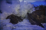
OK... Just for thought...
See the person up on the bluff???
The Tree on the right is approximately 40' high...
Soooo how big was this Wave to come ashore???
Any Guesses???
The mighty Pacific Ocean of the Oregon coast really lives up to that title at one spot on the south coast: Shore Acres State Park near Charleston / Coos Bay.
It�s known as the number one spot for oceanic fireworks and watery pyrotechnics, with waves that explode into the air well over 100 feet.
All it takes is the average heavy surf day, and maybe not necessarily one of those surf advisories from the National Weather Service.
Those waves get larger than you think. Some of them tower at 200 feet, even 300 feet high in some cases.
What causes this? What is it that�s different about Shore Acres State Park that makes breakers go so bonkers?
All this also begs the question: how do they measure these?
The explanation quickly tossed out for the big waves at Shore Acres is that it�s the tilted angle of the rock formation in front of the cliffs, and that the waves have nowhere to go than up.
That�s true, but there�s more to the story than that � it�s not that simple.
Some of these deeper details are known by scientists and some are still a mystery.
As two regional geologists told Oregon Coast Beach Connection,
it�s a combination of what seems to be a deeper ocean depth,
an incline that goes down towards the east, and the fact those waves hit a surface so suddenly.
They also don�t have much time between when they�ve turned into larger waves offshore and when they smack into in an object.
Ron Metzger is a geologist and geology professor at Southwestern Oregon Community College in Coos Bay.
He said the biggest difference here is the incline of the area underneath.
Most other Oregon coast spots have some kind of reef or slope that forms a ramp of sorts,
a ramp that gets higher as you go towards shore.
Here, everything is titled at a 40-degree angle but the opposite direction.
�If it was tilting west the wave energy would come in and it would just wash up that ramp,� Metzger said.
�Here, it�s the opposite of that.� In other words, things around here �
certainly the tilted rock in front of the cliff �
are pointed downwards to the east.
Then the wave energy does not have a chance to dissipate on an upwards incline.
Yet something about all this seems to be compressing the wave energy as well,
a bit like a spouting horn (like at Yachats or Depoe Bay)
squeezes the wave power into one place.
Metzger admitted he didn�t really know the full physics of the waves here,
nor was he certain of what exactly lay beneath the waves.
Some parts of this were also a mystery to University of Oregon geologist
and senior instructor Marli Miller, who is also the author of major books
like Roadside Geology of Oregon. Yet she had some interesting insights.
According to Miller and Metzger, there is a larger formation under here called a syncline �
a kind of massive dip in a V shape that surrounds the headland of Shore Acres.
It�s part of the faultline system, as Shore Acres is the product of a lot of folding
and moving around because of the two continental plates offshore.
This syncline may add to the action at Shore Acres. More likely, it simply has to do with the depth of the ocean around Shore Acres.
�I suspect there�s deeper water closer to Shore Acres than other parts of the coast,� she said.
�There�s a good chance it�s deeper because it gets down to a depth of 400 feet at a lesser distance from Shore Acres than anywhere else.�
Miller said there�s an area out at sea where everything drops to about 400 feet,
in and around the two plate boundaries that meet off this part of the coast.
This low depth spot is closer to Shore Acres than any other spot on the Oregon coast.
In other areas such as Brookings, Yachats or Seaside, those kinds of depths are much farther out.
So part of why the waves are so big is all that space underneath,
along with what seems to be a dip downwards.
Miller wasn�t sure of the depth right around this Coos Bay attraction,
however, but it helps explain more of the wave physics here.
She explained further: �Waves have a short period of time where they�re deep ocean waves,
and then they�re suddenly growing, and they grow to really large sizes as they get closer to the coastline,�
�They don�t really break early or anything like that.
There�s a shorter distance over which they grow and break and
I think that allows them to be bigger waves. �I think it has something to do with the depth of the water.
The shelf is narrower here, so there�s some reason to believe that.�
Miller said with a combo of elements like these,
it likely wouldn�t take the waves to be very big before they become �spectacularly so.�
So how do these waves get measured at Shore Acres?
Steven Michael is a local resident who is a photographer that documents all this
and he�s largely the one that�s been measuring these for years.
�A small group of us photographers came up with the process,� Michael said.
�And I have just kept it going. All measurements have been based on images I have taken.
Some people have sent me their images and asked to see how high it is.�
First, the measurements utilize the fact the cliff itself is about 75 feet high,
but it�s still an approximation.
�The height is determined by the comparison of the cliff,� Michael said.
He then points to a sampling of his own photos and notes all this depends on the angle
and where a photo was taken from.
In a photo editing program, you have to separate the wave from the scene and move it around in relation to the cliff.
�If you take the cliff and stack it,
you get approximately 150 feet,� he said. There are some other calculations that go into it as well.
�To find out which wave is higher than another it is quite simple.
We lay one photo on top the other, fade one out by 40%,
line up the cliff and either increase or decrease the faded image in order to match up the point on the cliff.
Then it is easy to determine which one is taller.�
Most waves seem to clock in at 100 to 150 feet.
Some reach much higher though!!!
The current record holder is from March 2016 at approximately 320 feet!!!
WOWWWWZAAA!!!
(C) William G. Hartshorn www.WGHartshorn.com All images are protected by copyright law.