South Fork Sauk River
The Mountain Loop Highway is a highway in the U.S. state of Washington. It traverses the western section of the Cascade Range within Snohomish County. The name suggests it forms a full loop, but it only is a small portion of a loop, which is completed using State Routes 92, 9, and 530. Part of the highway is also a designated and signed Forest Highway, and is known as Forest Route 20.[1]
The highway connects the towns of Granite Falls and Darrington. It is paved for 34 miles (55 km) from Granite Falls to Barlow Pass (2349') where the highway becomes unpaved for 13 miles (21 km), and then paved again for the remaining 9 miles (14 km) to Darrington. The unpaved section is U.S. Forest Service Road #20 and passes several USFS campgrounds. Portions of the unpaved section are often closed for periods of several years due to flood damage.
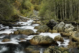
Between Granite Falls and Barlow Pass, the highway passes Big Four Mountain and the trailhead leading to the Big Four Ice Caves at its base. At Barlow Pass, a gravel road maintained by Snohomish County[5] (closed to motor vehicles) branches from the highway and leads to the former silver mining town of Monte Cristo. The portion from Granite Falls to Barlow Pass follows the Stillaguamish River. The portion from Barlow Pass to Darrington follows the Sauk River. The "inside" of the highway's namesake loop is a large area containing significant Cascade peaks, including Three Fingers (6850 ft, 2088 m), Whitehorse Mountain (6850 ft, 2088 m), Mount Dickerman (5723 ft, 1744 m), and Mount Forgotten (6005 ft, 1830 m).