All the rocks exposed in the area of Southerndown are sedimentary rocks. They were laid down as deposits of mud silt, sand and lime that, over long periods of time, were compacted and solidified into limestone, shale (compacted mud) and conglomerate (a rock comprising rounded pebbles of various sizes).
The oldest rocks are hard, grey, often shelly, Carboniferous limestones. These were laid down in a warm, shallow sea during the early part of the Carboniferous Period when Wales lay just south of the equator. Subsequent earth movements have folded and fractured the crust, and during the next 100 million years they suffered extensive erosion. These earth movements left the upfolded Carboniferous limestones as an area of high ground, extending through what is now the Vale of Glamorgan.
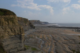
During the early Jurassic Period, a shallow sea spread northwards over the land. As the water deepened the higher areas became islands before they finally became inundated. The water depth influenced the kinds of sediments that were deposited. Rocks formed close to the shore (Sutton Stone and Southerndown Beds) are strikingly different from the Blue Lias, which was deposited at the same time but farther offshore. The Sutton Stone consists of massive, white, conglomeratic limestones with pebbles of black chert (silica) and carboniferous limestones. The overlying Southerndown Beds are blue/grey conglomeratic limestones and limy sandstones with thin shale partings. The Sutton Stone and Southerndown Beds pass laterally into, and are overlain by, the alternating blue-grey limestones and shales of the Blue Lias. The Jurassic rocks are generally rich in fossils. Shells of bivalves, and ammonites, fragments of crinoids, corals and pieces of carbonised fossil wood are quite common.
During the last 200 million years further earth movements have caused folding and fracturing of the Jurassic rocks and, since the end of the last Ice Age, the present coastline has been shaped by subaerial and marine erosion, both of which continue today.[2]