This is an English map of Scottish fortifications in the West March - a military intelligence map to plan possible war on Scotland. England has never been a "friend" of Scotland.
Scroll down to "other sizes" and click on "original" to view a larger version of the map for greater details.
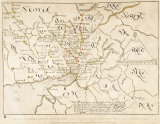
In looking at an enlargement of the map I discovered that there were some differences among the symbols used to designate a castle or fortalice. I decided to color code the structures to see if there was a pattern. Those with a cross on top are filled in with red. The ones lacking a cross and topped with a peak are filled in with yellow. The simplest of symbols consists of a circle topped by square and filled in with green. All of these fortalices are further identified by what I believe to be a code: 1) circle and square are blank, 2) circle has a dot in the center while the square is blank, and 3) both the circle and the square have a dot in the center. There is no instance in which the circle is blank and the square has a dot. I feel certain that this is a code of some sort, but I have not yet looked into what these dots indicate. The substantial castles are filled in with orange. Newbie castle is filled in with blue. This was the coastal extremity of the influence of Clan Johnstoun.