


|
|
|
|
|
|
| |
| 30-APR-2018 | Cliff. Johnston |
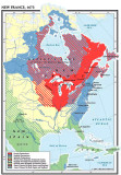
This is one of the best maps that I have seen, giving us an excellent oversight as to who controlled (or didn't control) what areas in North America in 1673. Very interesting, IMO.
We need to assume that the solid yellow-colored areas are unclaimed.
I wish that I could give an attribution for this map, but it was on a post with no credit given. If anyone knows the source, please, let me know.
Moments-In-Time
| comment | |