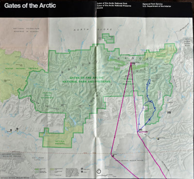
On this map of Gates of the Arctic National Park, I have marked a couple of flight routes. The magenta lines represent our flights from Fairbanks up to Bettles (underlined in magenta), with stops at Allakaket and then Anaktuvuk Pass (which is actually within Gates of the Arctic NP) to drop off and pick up people/freight (including a refrigerator) before heading back South to Bettles. The rest of the magenta route is our flight the next day back to Fairbanks. The marked blue route is our flight from Bettles to the "Gates of the Arctic" that the park is named for, Frigid Crags (on the left/Western side) and Boreal Mountain (on the right/Eastern side). From there we flew back to Long Lake where we landed on skis and then back to Bettles.