


|
|
|
|
|
|
| |
| 19-OCT-2015 | |
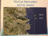
Note how flight path passes through SSTIK and then almost through SEPDY, the prior waypoint.
The new SSTIK flight path goes well north of the Brisbane triangular lagoon and almost to the land that juts out to the right, the Candlestick Park area. The flight path returns to the left and then down cutting to the left end of the Brisbane industrial park and the quarry. Note how the flight stays away from Brisbane.
How does this flight path simulation compare to where the flights actually fly?