


|
|
|
|
|
|
| |
| 28-MAY-2015 | |
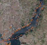
The blue line is a GPS track of our two-hour cruise up the Bosphorus Strait.
We boarded our ferry at Eminönü Haliç İskelesi on the lower left of this map. We traveled along the European shore until we reached the Fatih Sultan Mehmet Bridge, the second bridge linking Eurpope and Asia. On the return trip, we traveled along the Asian shore.
Copyrighted © 2003 - 2022 by Peter Kwok. Images may not be reproduced for commercial purpose without written permission.