photo sharing and upload picture albums photo forums search pictures popular photos photography help login
Flying Dutchman | all galleries >> Please visit jpcvanheijst.com >> Boeing 747 > Chart plotting over the Atlantic
previous | next
08-MAR-2015

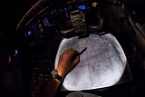
Chart plotting over the Atlantic

Crossing the North Atlantic Tracks (NAT) at night. Still plotting our course on the navigation charts by hand. Waypoints, parallel tracks and Equal Time Points (ETP's) between enroute-alternates, including fuel checks along the route.
747-400 from New York to Luxembourg.

Nikon D800
1/50s f/5.6 at 10.5mm iso3200 full exif

other sizes: small medium large original auto
share
Gary A. Rich (GRainelev)18-Mar-2015 20:20
Isn't technology great!!!! I know the large ocean going vessels, still plot their course on maps, even though they have a computer doing it!!!! It is a matter, what really works. I am still amazed by images inside the cockpit. You have the night scenes down pat. V.
Type your message and click Add Comment
It is best to login or register first but you may post as a guest.
Enter an optional name and contact email address. Name
Name Email
help private comment