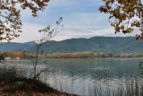
The Banyoles drainage basin separates the plain of l'Empordŕ from the Transversal mountain chain, which lies in the region of la Garrotxa. Apart from the main lake of Banyoles, there is a series of smaller surrounding lakes, including el Vilar, d'en Sisó, la Cendra and el Clot d'Espolla. The main lake of Banyoles is one of the largest lakes on the Iberian Peninsula, with a surface area of 107 ha and an unusual figure-of-eight form. It has a length of 2,128 m, a width of 775 m and a depth in some points of greater than 40 m. The origin of the lakes and the source of the waters feeding into it are perhaps the most interesting aspects of this lake system. The mountains in the region of l'Alta Garrotxa, to the north, collect the fairly frequent rains of that sector. The water filters down into an aquifer and runs underground through channels formed in the calcareous rock of the region. Fractures in the limestone which carries these underground rivers release the water towards the surface at certain points. This occurs for the Fluviŕ river in the valley of Sant Miquel de Campmajor and for the group of lakes in the basin of Banyoles. Whilst this underground system of water supply might seem unusual, the process of formation of the smaller lakes is even more so. As the water passes through the underground channels, it dissolves the calcareous rocks and clays lying under this zone. This eventually causes the collapse of the surface and the formation of a new lake.


Please login or register.