photo sharing and upload picture albums photo forums search pictures popular photos photography help login
Dave Beedon | all galleries >> Places >> Utah >> Moab (environs) >> Sand Flats >> Looking for Morning Glory Natural Bridge > As close as I could get
previous | next
18-SEP-2007 20070918_2809

As close as I could get

Sand Flats Recreation Area (Moab, Utah) view map


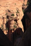
The goal of this hike was to look down upon Morning Glory Natural Bridge from the fins above it in the Sand Flats Recreation Area. This is as close as I could get. The bridge is hidden behind the rock features at bottom left, in line with the narrow ridge at left marked with a black dot. At right, in shadow, is a narrow corridor containing trees. That is the approach route for people who rappell next to Morning Glory Natural Bridge, ending up on the canyon floor below the bridge.

This view is to the southeast from a narrow corridor between two fins.

Nikon D80
1/400s f/8.0 at 130.0mm iso100 full exif

other sizes: small medium original auto
share
1moremile27-Mar-2014 22:32
Wow. I didn't realize how far away that was until I realized
those are trees. Great picture.
Type your message and click Add Comment
It is best to login or register first but you may post as a guest.
Enter an optional name and contact email address. Name
Name Email
help private comment