photo sharing and upload picture albums photo forums search pictures popular photos photography help login
Dave Beedon | all galleries >> Places >> Utah >> Moab (environs) >> Sand Flats >> Looking for Morning Glory Natural Bridge > Abyss and Echo canyons
previous | next
18-SEP-2007 20070918_2557

Abyss and Echo canyons

Sand Flats Recreation Area (Moab, Utah) view map


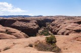
This looks about southwest from the fins of Sand Flats Recreation Area. Straight ahead is Abyss Canyon, which dead-ends in the distant shadow. Its closer portion angles to the right to join Negro Bill Canyon, but that portion is obscured by the foreground rock.

The shadowy canyon at left is Echo Canyon, a branch of Abyss. Together thy form a Y. The undulating sandstone terrain above the canyons contains the Slickrock Bike Trail and the Hell’s Revenge 4x4 trail.

The patch of dirt in the foreground is about seven feet wide and the bush about three feet tall.

Nikon D80
1/800s f/5.0 at 18.0mm iso100 full exif

other sizes: small medium large original auto
share
Lee G26-Mar-2014 01:20
I'd like to ride Hell's Revenge. Maybe in the Fall, after the Summer vacationers have departed the Moab area.
Type your message and click Add Comment
It is best to login or register first but you may post as a guest.
Enter an optional name and contact email address. Name
Name Email
help private comment