


|
|
|
|
|
|
| |
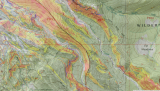
Shows where Newton Creek runs near the left bank (looking upstream) , which may require skiing above the bank in the trees , not as fun.
The first marker just shows the start at Elk Meadows & Newton Creek, since the trail was not that visible at first when I lowered the opacity of that layer to show more of the satellite view.
It also shows that the hiking trail starts out between the creek and the high ridge (marked as the wilderness boundary), and then going to the left of a a smaller ridge which starts higher up, and then climbs up onto the ridge. If you want to go further up Newton Creek without dealing with dropping off this ridge it is important to stay to the right of it.
That ridge blends into the the higher ridge. I have skied on the higher ridge, dropping off it where the trees fade. At that point the higher ridge is wide and open and longer, coming to this smaller ridge where it has a narrower open path down to Newton Creek, if you don't traverse beyond where it has faded, and I think it is even steeper. Some (most?) telly skiers ski further along the higher corniced ridge before dropping down near the "Gates of the Mountains", and after this second ridge has completely blended into the side of the higher one
The colors indicate steepness (and avalanche danger) see map added later for color code
All images are copyrighted, please request before using