


|
|
|
|
|
|
| |
| 16-Jun-1997 | |
from Wikipedia:
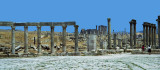
Jerash, the Gerasa of Antiquity (Ancient Greek: Γέρασα), is the capital and largest city of Jerash Governorate (محافظة جرش), which is situated in the north of Jordan, 48 kilometres (30 mi) north of the capital Amman towards Syria. Jerash Governorate's geographical features vary from cold mountains to fertile valleys from 250 to 300 metres (820 to 980 ft) above sea level, suitable for growing a wide variety of crops.
In the latter Ottoman period, the city of Jerash's name was abandoned and changed to Sakib, yet this was not a permanent development, as the name "Jerash" reappears in Ottoman tax registers by the end of 16th century.
A strong earthquake in 749 AD destroyed large parts of Jerash, while subsequent earthquakes along with the wars and turmoil contributed to additional destruction. Its destruction and ruins remained buried in the soil for hundreds of years until they were discovered by German Orientalist Ulrich Jasper Seetzen in 1806.[4] He began excavation and a return to life of the current Jerash by inhabitants of older villages. 70 years later, this was followed by the Muslim community , Circassians, who emigrated to Jordan from the Caucasus in 1878 after the Ottoman-Russian war. Subsequently a large community of people from Syria came to the area at the beginning of the 20th century.
Images are best viewed in "original" size. © by The Ellisons: if you wish to use/purchase an image pls contact us through PBase.