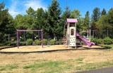
The panel in front of the slide is a climbing wall. Affixed to it are the same kind of artificial handholds that are used on large-scale climbing walls. I thought this was a cool idea for a playground.
My vantage point is at the center of this WikiMapia aerial view. In that imagery, the trail is nearly covered with strange round things. The round things are huge sandbags that were put there to deal with the possibility of flooding due to failure of the Howard Hansen Dam. The dam had developed some leaking that might have led to collapse during heavy rain (which never came). The sandbags were installed in Fall 2009 and removed in Fall 2012 after the dam had been repaired. While they were in place, the trail was open only to pedestrians.
Photographed from the Green River Trail with an iPhone while seated on my recumbent trike.