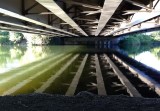
Shot from the seat of my recumbent trike on the Green River Trail in Tukwila, Washington. Overhead is Tukwila International Boulevard. The highway used to be called �Pacific Highway South� but in 1998 it was changed for political reasons. At one time it also carried the �State Route 99� label.
Why is the Green River Trail following the Duwamish River? At a confluence upstream from here, the Green becomes the Duwamish. The Duwamish River flows leftward into Elliott Bay in Seattle, a body of salt water. Thus the river is affected by tides. When I took this picture, the tide was coming in. The upstream flow was strong enough to create little eddies along the edge. I sat here for a few minutes watching the river flow.
Google Earth and Wikimapia label the highway with both names. Bing Maps still calls it �Pacific Highway South.� The Thomas Guide �King, Snohomish, and Pierce Counties Street Guide� label it with its current name.
iPhone photo.
|