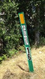
I passed several such signs while riding my recumbent trike on the Green River Trail. All were marked “City of Kent,” so I assumed they had been installed by the city. My assumption was wrong. Through e-mail correspondence with Lynn Osborn of Kent’s parks department, I learned that they were not installed by the City of Kent, but by the Army Corps of Engineers and are designed as reference points during levee reconstruction (or something like that). Thanks, Lynn!
That made me wonder where Corps started measuring the river’s miles. The location of the mouth of the river is not an obvious thing because the Duwamish River (the name of the Green River downstream) splits at Harbor Island, flowing into Elliott Bay in two separate channels.
Some research yielded this information from the US Army Corps of Engineers: this sign is 16 miles upstream from the mouth of the Duwamish River. (The Green River becomes the Duwamish River in Tukwila, where Springbrook Creek flows into it.) The mouth of the Duwamish is on the west side of Harbor Island, about 0.3 miles downstream from the Spokane Street Bridge. That’s where the river makes a 45-degree bend to the north and becomes the West Waterway.
Levee re-construction was completed in 2015 or 2016 and the area looks very different---all the greenery visible in the photo has been replaced by a sterile concrete flood wall. And the post is gone.
This iPhone 5 photo was taken while seated on my recumbent trike.
|