


|
|
|
|
|
|
| |
| 22-MAR-2013 | Jola Dziubinska |
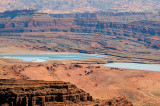
Looking east most of the potash evaporation ponds at Potash, are visible here.
The Moab or Cane Creek potash mine is located along the right (northwest) bank of the Colorado River, about 20 miles (30 km) west of Moab.
River water is pumped into the mine and dissolves the potash, after which the brine solution is pumped to evaporation ponds.
These images may not be used in any form without permission. Copyright © 2004-2023 Jola Dziubinska. All Rights Reserved.
Please login or register.