Castle Mountain (Alberta)
2766m (9076ft.)
Located in the Bow River Valley west of Silverton Creek and opposite Vermilion Pass. Banff Park, Alberta
Latitude 51; 18; 20 Longitude 115; 56; 20, Topo map 82O/05
Panorama viewpoint: Storm Mountain Hill. Can be seen from Highways 1 and 93S
Named by James Hector in 1858. The mountain was named for its fortress or castle-like appearance. Official name. Other names Mount Eisenhower
First ascended in 1884 by Arthur P. Coleman
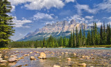
Photo: Looking northwest to (l-r) Castle Mountain, Stuart Knob, and Helena Ridge from the Trans-Canada Highway
More photos
Other Information
Photo: Looking north-northwest to Castle Mountain (Eisenhower Peak at right) from the Bow Valley
James Hector was still nineteen kilometres down the Bow Valley from what is now known as Castle Junction when he decided what the name of this mountain should be. He wrote, "Seeming to stand out in the centre of the valley is a very remarkable mountain... which looks exactly like a giant castle." When Sir Sandford Fleming travelled up the valley during the construction of the CPR he seemed to agree with the appropriateness of the name, writing, "Westward we see Castle Mountain to our right. The resemblance to Cyclopean masonary has doubtless suggested the name, for it is marked by huge masses of castellated-looking work, with turreted flanks."
One of the most imposing peaks in the Bow Valley, the bold, castellated southwest front of the mountain dominates the view for much of the journey from Banff to Lake Louise, its bulk, prominent position as noted by Hector, and reddish colour combining to make this a favourite of many who pass this way.
Two levels of steep cliffs form the "castle" part of Castle Mountain. The ledge between is the Stephen Formation which correlates westward to the rocks that contain the Burgess Shale fossils in Yoho National Park.
_DSC7970pb.jpg