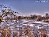
Misterieuze cirkelvormige patronen in het ijs van de "Wiel van Bassa", vlakbij Leerdam.
Dit binnenmeer is ontstaan na een dijkdoorbraak in 1573. De wiel ligt aan de "Diefdijk" tussen Schoonrewoord en Leerdam.
Deze dijk maakt deel uit van de oude Hollandse waterlinie. In het jaar 1573 brak de dijk door en is deze Wiel (binnenmeer) ontstaan.
De Schoonrewoerdse wiel is tegenwoordig een natuurgebied, en is zo’n 13 ha groot.
Mysterious circular patterns in the ice of the "Wiel of Bassa", near Leerdam.
The "Wiel" is located along the dike between Schoonrewoord and Leerdam. This dike is part of the old Dutch "Waterlinie".
In the year 1573 the dike broke and this Wiel (lake) was born.
The "Wiel van Bassa" is now a beautiful nature reserve and is about 13 hectares.
Over the old Dutch "Waterlinie"
In 1589 (after the 1573 dam-break) came the first time the idea of flooding large parts of Holland,
to defend the richer more populated parts of the Netherlands simultaneously.
Through the flooding of large parts of land, it became more difficult for the enemy, to cross this huge water mass.
The intake points for water used to create the line, were defended by fortifications,
and so were the elevated roads (access points). So relatively few troops could defend the Waterline.