


|
|
|
|
|
|
| |
| 02-DEC-2011 | |
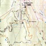
The trails I am talking about are marked with a this red-orange line, not to be confused with the PCT 2000 trail to the east.
He shows this area as intermediate. The cross country route next to the Timberline Rd does cross avalanche slopes though, and some may find traversing this part or skiing through the downhill area difficult.
I skied to this trail from the yellow jacket trail, the connection between would be the hardest part, it would also make a long day.
I recently skied down through the ski area and crossed the TL road and skied down and across and then upto the road.
I have also skied down from the "climber's?" parking lot (going up first to reach the bottom of the Salmon Creek). That day was icy, except where it was sunny to the East, so I was a bit further East than what now seems like the easiest way. I turned around rather than cross the 2nd creek since the avalanche danger was suppose to increase with warming that day.
It might make a fun loop from TL to white river, though a long one.
All images are copyrighted, please request before using