


|
|
|
|
|
|
| |
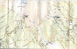
This map shows ski trails to the East of theTL road.
The dashes are supposed to be trails, and the dots cross country.
In this case these are no longer marked (if they ever were). The dashes for the most part seem to be on roads, the dots thru the woods.
The next map is a crop of this area, where I have marked the trails in red.
I would wait for more snow if coming from the yellow jacket trail, to cover the small trees in the clear cut, or go through more mature woods.
I would ski the timberline area during the week if possible. Less skiers and the Puci lift has been closed so far. Also crossing TL road would be easier with less traffic. Right now the banks are low enough that I did not have any problem crossing using their poles for balance, tramping the snow down and sitting down, and dropping at most a foot down to the pavement, I kicked in one or two foot set steps opposite and used the pole to pull myself up onto the bank , I am 5' 9". I think the road might be even wider just a bit further down, though it is wide enough where I was, there were no parking signs down there, maybe a plow turn around spot.
All images are copyrighted, please request before using