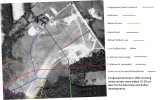
I forgot to put Halpine Road (dark red) and Evelyn Dr (light purple) in the caption. Residents of Montrose or Rollins who are familiar with the street layout may notice that this 1951 photo shows a grove of trees on the NNE edge of where Martha Terrace was built about 1961-1962. It is in about the same location as the grove of trees in Montrose Park between Martha Terrace and the park basketball court. This may be the only remaining recognizable feature in the airport that still exists today.
Locations of the streets are approximate. I used the Windows 'Paint' utility to draw these streets in using a 1970 aerial photo (also in this gallery) to identify street locations. By running two copies of Paint, one with the 1951 image and one with the 1970 image, overlaying them and matching up three features that existed in both pictures (but not now), I was able to approximate where the streets lay. The 3 features were the Penn-Jersey building on Rockville Pike, the Congressional La/Rockville Pk intersection and the aircraft hangars that still existed in 1970. By alt-tabbing from one image to the other, I drew in the streets on the 1951 image.