


|
|
|
|
|
|
| |
| © 2011 Bob Walker | |
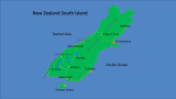
The map shows some of the places we stopped on our 2 week tour of the South Island.
The route we took started in Christchurch, and from there we went to Kaikoura, Arthur's Pass, Fox Glacier,
Lake Moeraki, Wanaka, visited a sheep farm near Garston, to Te Anau, Milford Sound, back to Te Anua
and Invercargill, where we took a small plane flight over to Stewart Island.
While on Stewart Island, we visited the Ulva Island Bird Sanctuary. Then we left back for the South Island,
to Invercargill, through the Catlins area to Dunedin. We returned home from Dunedin.
| comment |