


|
|
|
|
|
|
| |
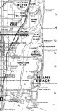
| 1925 | Courtesy of Alvin Lederer |
Thank you to Alvin Lederer for contributing this great old 1925 map of Miami and surrounding environs depicting current status and projected 1935 growth.
Note that "South Beach" is south of 5th Street on Miami Beach and that "North Beach" is immediately north of Lincoln Road. Due to the value of the name somehow South Beach now extends north of Lincoln Road!
I wonder where the U. S. Coast Guard Station east of Normany Isle disappeared to? Did Charles Deering have another estate on the bay between Lemon City and Buena Vista? It appears that Fisher Island was named "Peninnsula Island" at the time.
Please click on "original" below to see the image at the largest size.
Unless otherwise noted under the right bottom of the photo, all images are copyrighted by Don Boyd
| comment | |