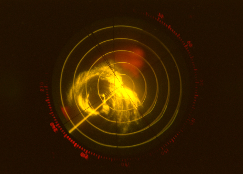
| As the Navigator, I had many jobs. I had to flight plan the mission and make sure we loaded enough fuel to do the job. I had to keep track of our position and make sure we didn't get lost (the Pacific Ocean is a mighty big place, and it doesn't come with helpful highway signs). Working with the Flight Engineer, I had to compare how much fuel we had left with how long it would take us to get home. I had to answer everyone's questions: "Hey Nav, what island is that?" or "Hey Nav, are we there yet?" or "Hey Nav, what's the square root of 556.6?". The job that was the most fun was actually finding the center of the typhoon or hurricane. One tool I used was the search radar, shown above. This is Typhoon Dinah in July of 1984. We are about 450 miles northeast of Guam. Precipitation (rain) is shown as bright yellow-orange blobs. Notice the familiar spiral pattern. The radar is set on a 50 mile range, so each "ring" on the radar is 10 miles apart. We are heading southwest (the long straight bright line is our heading, and north is at the top). Since we are at the center of the 'scope, we can learn alot about the storm just by looking at this picture. See that ring about 20-30 miles in front of us? That's the eyewall. It's pretty well-defined, and fairly complete. That, plus the fact that its about 10 miles in diameter means that this is a fairly robust storm (the tighter an eyewall, the more powerful the storm). Also, notice how you can't see anything past 40 miles or so? That's because the rain directly in front of us is so heavy that its blocking out the radar returns from farther away. That means we'll probably get a bumpy ride on our way to the eye. (More pictures of Typhoon Dinah later!) |