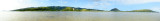
This panorama was stitched from 8 shots using Photoshop Elements.
The shots were taken about 100 yards off shore standing in the ocean at low tide and covers about 200 degrees.
Diamond Head is on the far left and Koko Crater followed by Koko Ridge with China Walls at the tip is on the far right.
The east end of the Koolau mountain chain is in the center of the picture with Kuliouou Valley mid center.
During very low tide the water level at the eastern end of the Bay is less than a foot for over 150 yards off shore.
Much of this is due to silting caused by a huge storm several years ago that dumped huge quantities of dirt into the Bay.
This has threatened the native coral reef and is also causing the incursion of alien algae species which overwhelm the more naturally occuring species.