The main island has the same name of the archipelago: Fernando de Noronha.
Fernando de Noronha has 17 km˛, with a length of about 10 km and a maximum width of 3,5 km. Its perimeter has about 60 km.
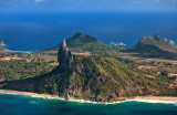
The island is uneven, has various elevations, of which the most important are: the Morro do Pico (Peak Mount) with 323 m hight; the Morro do Espinhaço (Spine Mount) with 223 m; the Morro do Francęs (Frenchman Mount) with 195 m; the Alto da Bandeira (Flag Height) with 160 m; the Morro do Curral (Farmyard Mount) with 126 m; and the Morro de Sto. Antônio (Saint Antony Mount) with 105 m.