


|
|
|
|
|
|
| |
| 05-SEP-2009 | |
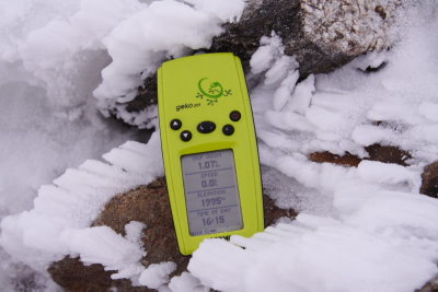
The actual altitude of Mt Bogong is 1986m, my GPS
doesn't have a true altimeter and therefore has
an error range of +- 30m elevation.
| Full EXIF Info | |
| Date/Time | 05-Sep-2009 16:09:46 |
| Make | Canon |
| Model | Canon EOS 350D DIGITAL |
| Flash Used | No |
| Focal Length | 41 mm |
| Exposure Time | 1/250 sec |
| Aperture | f/7.1 |
| ISO Equivalent | 100 |
| Exposure Bias | 1.00 |
| White Balance | |
| Metering Mode | (-1) |
| JPEG Quality | |
| Exposure Program | shutter priority (2) |
| Focus Distance | |
© Copyright Tom
| comment | |